Showing posts with label Floods. Show all posts

Humans are still significantly better at predicting the weather than AI

Artificial intelligence is present in almost every aspect of our daily lives. It's used in search engines, email clients, media platforms, and even grocery chains worldwide. It arguably makes the world a more efficient place, but not without costs; job loss being one of them. However, there is one industry that still struggles to fully automate: weather forecasting.


Despite all the progress that has been made in the realm of technology, AI, and machine learning, weather companies have not yet handed over the keys to their computer counterparts. While AI models, with the help of weather satellites like GOES-16 and 17, are capable of predicting minor weather changes and patterns with surprising accuracy, their efficiency takes a steep dive when major climate disruptions occur.

These major weather shifts, including natural disasters, often have warning signs that are too subtle and small in scale for most models to detect. Even when they are detected, models can't always draw correlations between early indicators of, say, a waterspout and its likely arrival. This, Wired reports, usually requires the practiced eye of an industry veteran. The outlet claims that, based on over two decades worth of weather prediction information (gathered by the NOAA Weather Prediction Service), humans outperform two of the most popular national weather prediction models; the Global Forecast System and the North American Mesoscale Forecast System.

By how much? Between 20 and 40 percent.

That is no small gap, and it could easily mean the difference between life and death for those in the path of a vicious tornado, waterspout, or rapid-onset blizzard. Having access to accurate weather information as early as possible is what makes evacuation (where necessary) or shelter-in-place recommendations viable.

Seasoned weather veterans can look at the smallest details, like subtle shifts in atmospheric pressure, wind speed, or "available moisture," and draw higher-quality conclusions than their computerized counterparts. This is because, in many cases, weather prediction models don't weigh these measures as highly.

And frankly, that's no surprise. Computers are smart and getting smarter by the day, but they still lack something humans have always possessed: the ability to evaluate situations in a broader context. Bringing machines anywhere near parity with human memory and context awareness would require an immense amount of processing power that just isn't available widely at the moment. Only a handful of computers that might be capable of this are in development right now -- at least, in the US -- and weather groups aren't the only ones that want to use them.

In short: humans are actively being replaced across dozens of industries at an alarming rate, but for now, your local weatherman (or at least the group feeding him his data) is safe.

By  

ENSO và tác động đến thuỷ văn, nông nghiệp


Ảnh hưởng của ENSO đến độ mặn nước biển vùng ven biển và hải đảo Việt Nam.
Một cách tương đối, ảnh hưởng của El Nino làm tăng độ mặn, trái lại La Nina là giảm độ mặn của nước biển ở vùng ven biển và hải đảo nước ta.

Ảnh hưởng của ENSO đến dòng chảy sông ngòi ở Việt Nam.
- Trong những năm El Nino, phần lớn các trạm có dòng chảy năm nhỏ hơn trung bình nhiều năm từ 10% trở lên, những năm El Nino mạnh có thể giảm tới 50 - 60%.

- Trong những năm La Nina, dòng chảy năm các sông thường lớn hơn trung bình nhiều năm, có năm, ở một số sông, lớn hơn tới 80 - 100%.

- Đối với dòng chảy mùa lũ cũng có đặc điểm tương tự: trong những năm El Nino thường nhỏ hơn giá trị dòng chảy trung bình nhiều năm, tỷ lệ (%) giữa dòng chảy mùa lũ và dòng chảy trung bình nhiều năm đạt 65 - 95%, trái lại, trong những năm La Nina, tỷ lệ này thường là 101 - 110%, ở một số vùng lên tới 130 - 140% (vùng núi Bắc Bộ, Trung Bộ và Tây Nguyên). Tuy nhiên, tính biến động của đặc trưng này trong điều kiện ENSO rất lớn, không loại trừ có năm El Nino, dòng chảy mùa lũ lớn hơn dòng dảy trung bình nhiều năm, ngược lại, trong những năm La Nina, dòng chảy mùa lũ nhỏ hơn dòng chảy trung bình nhiều năm.

- Đối với dòng chảy mùa cạn, trong những năm El Nino, lượng dòng chảy 3 tháng liên tục nhỏ nhất ở hầu hết các trạm đều nhỏ hơn trị số trung bình nhiều năm của thời kỳ tương ứng và đạt khoảng 80 - 90%, trái lại, trong những năm La Nina - lớn hơn trị số trung bình nhiều năm và đạt 101 - 140%. Đối với dòng chảy tháng nhỏ nhất cũng có tình hình tương tự.

Phải nhấn mạnh rằng, các tác động của El Nino và La Nina ở Việt Nam là rất phức tạp và không mạnh mẽ như ở khu vực Indonesia và Philippine hay Australia.

Ảnh hưởng của ENSO đến sản xuất nông nghiệp.
Xét một cách tương đối, trong điều kiện El Nino, năng suất lúa bình quân của vụ Đông Xuân giảm so với vụ trước đó, nhất là ở vùng trung du Bắc Bộ, trái lại năng suất lúa vụ mùa tăng, nhất là ở vùng Bắc Trung Bộ.

Một quan hệ tương tự và không thực sự chặt được xác định đó là trong điều kiện La Nina, năng suất lúa bình quân vụ Đông Xuân và vụ mùa đều tăng so với vụ trước đó, trong đó vụ Đông Xuân rõ nhất ở đồng bằng Bắc Bộ, vụ mùa rõ nhất ở đồng bằng sông Cửu Long.

Một số giải pháp nhằm hạn chế tác động xấu và thiệt hại do ENSO gây ra
Ngoài các giải pháp công trình liên quan đến thủy lợi, rừng phòng hộ, bảo vệ giải ven biển..., các giải pháp phi công trình chủ yếu là:
- Quy hoạch và quản lý tổng thể các lưu vực sông, hệ thống các hồ chứa nước.
- Điều chỉnh cơ cấu sản xuất, mùa vụ ở một số vùng nhằm thích ứng với ảnh hưởng của ENSO.
- Xây dựng và hoàn thiện các phương án theo dõi, cảnh báo, dự báo tác động của ENSO.
- Tăng cường công tác tổ chức, quản lý thiên tai của Nhà nước và của các ngành đối với tác động của ENSO như một bộ phận của chiến lược quốc gia về phát triển bền vững.

- Tiếp tục tăng cường công tác tuyên truyền, nâng cao nhận thức cho công chúng về ENSO và những giải pháp phòng tránh.


Climate change in Vietnam

flood, climate change, vietnam

Increasing atmospheric concentrations of green house gases (GHGs) result from emission GHGs of human activities has raised much serious concern and attention of the world recently. Climate change impacts on the ecological environment, threats to our daily lives and routine industrial activities.
Beyond to these danger and challenges, the United Nations Framework Convention on Climate Change (UNFCCC) sets the general framework for international efforts to address climate change. The UNFCCC was opened for signature in 1992 and entered into force in 1994. The ultimate objective of the UNFCCC is to achieve stabilization of atmosphere concentrations of greenhouse gases at a level that would prevent dangerous anthropogenic interference with the climate system.

Các thiên tai Khí tượng thủy văn ở Việt Nam

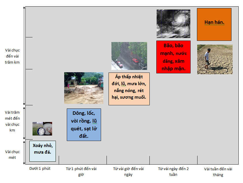
Theo Quyết định 46/2014/QĐ-TTg về Quy định về dự báo, cảnh báo và truyền tin thiên tai, có 7 nhóm thiên tai chính được dự báo, cảnh báo và truyền tin trên lãnh thổ Việt Nam. Trong số các thiên tai được dự báo, cảnh báo, có các thiên tai liên quan đến hiện tượng khí tượng thủy văn như: áp thấp nhiệt đới, bão, lũ, lốc, sét, mưa lớn, lũ quét, ngập lụt, sạt lở đất do mưa lũ hoặc dòng chảy, sụt lún đất do mưa lũ hoặc dòng chảy, nước dâng, xâm nhập mặn, nắng nóng, hạn hán, rét hại, mưa đá, sương muối.
Các thiên tai khác nhau có những đặc trưng về quy mô không gian và quy mô thời gian khác nhau được tổng hợp trong hình 1. Những xoáy bụi nhỏ hay mưa đã có thể xảy ra trong vài phút và ở một khu vực nhỏ khoảng vài chục đến vài trăm mét. Những trận dông hay lũ quét có thể xảy ra ở quy mô lớn hơn nhưng cũng chỉ kéo dài vài giờ. Đối với áp thấp nhiệt đới, mưa lớn, lũ hay nắng nóng có thể xảy ra trên diện rộng từ vài chục đến vài trăm km và kéo dài trong vài giờ cho tới vài ngày; những cơn bão mạnh có thể duy trì lâu hơn kể từ khi hình thành đến khi tan rã. Trong dự báo, người ta căn cứ vào quy mô thời gian tồn tại của các hiện tượng để biết được hiện tượng đó có thể dự báo trước được bao lâu; đối với những hiện tượng xảy ra dưới một giờ như dông, lốc, mưa đá, lũ quét, sạt lở đất thì chỉ có thể cảnh báo trước một thời gian rất ngắn, tính bằng phút. Ngoài ra, quy mô không gian quyết định xem một hiện tượng có thể dự báo được hay không, nếu hiện tượng có quy mô dưới 10 km thì rất khó cảnh báo bởi các phương tiện đo đạc hiện tại không cho phép phát hiện ra những hiện tượng nhỏ như thế.

Deadly flash floods hit southern France

At least 19 people have been killed by flash floods in south-eastern France, officials say.
Several others have been reported missing after torrential rain hit the mountains above the Cote D'Azur region on Tuesday.
A number of towns in the department of Var were affected, with hundreds of homes flooded.
Meteo France, the national weather service, said up to 40cm (15.7in) of rain had fallen since Tuesday.
Meterologists say the floods are the worst in the region since 1827.
About 2,000 rescue workers have been drafted into affected regions around Draguignan - the worst-hit area - near the Mediterranean coast to help those trapped in their vehicles or houses.
'Devastated' Map of France Water levels were said to be falling slightly in Draguignan on Wednesday, though the rain was continuing in nearby Roquebrune and Frejus.
Meteo France has warned of further storms on Wednesday night.
"We have never seen so much rain in the month of June," Patrick Galois of Meteo France told the AFP news agency.
At least 1,000 people had to leave their homes and spend the night in schools or other temporary shelters, and some 175,000 houses were estimated to have been left without electricity.
Some reportedly sought shelter on the roofs of their homes, while helicopters were brought in to rescue people.
Rescue teams had to moved 436 inmates from a prison in Draguignan after two floors flooded.
The force of the water swept empty cars and other vehicles down streets in Draguignan.
"This morning, we woke up to find a town centre that was devastated, extremely battered with overturned cars floating in the streets, collapsed roads and gutted houses," said Corinne Orzechowski, the official leading the emergency operation.
Condolences Cars washed up by flood water in Draguignan, France, 16 June 2010 The floods are believed to be the worst since 1827 The BBC's Hugh Schofield in Paris says that many of those who died were caught in their cars.
Rail and air services in the region were interrupted, and about 300 passengers travelling on a high-speed train between Nice and Lille had been trapped by the flood waters, the AFP news agency reported.
The railway line between Toulon and Frejus will be closed until Thursday morning.
President Nicolas Sarkozy offered condolences to the families of the victims, and pledged his support to rescue workers "mobilising non-stop to provide aid and find those still missing".
He plans to visit the area early next week.