Cơn bão thứ 12, bão Damrey, ở biển Đông năm 2017 sẽ gây ra thời tiết xấu cho Đà Nẵng và Quảng Nam đúng dịp Việt Nam tổ chức thượng đỉnh APEC với sự tham dự của lãnh đạo 21 nền kinh tế thành viên.
Bão Damrey, với khí áp ở tâm là 970 hPa, ở phía nam mang theo hơi nóng và ẩm từ hướng đông vào, còn áp cao lục địa với khí áp tràn xuống khiến khí áp ở Bắc Bộ, trong đó có thủ đô Hà Nội tăng lên mức 1020 hPa. Hai khối áp thấp và áp cao này khi tiếp cận nhau khiến chênh lệch khí áp trong một khoảng cách nhỏ tăng đột biến (hay nói cách khác gradient khí áp tăng mạnh) khiến gió ở vùng rìa phía Bắc của cơn bão càng mạnh thêm lên. Nhiều khả năng bão số 12 đạt cường độ mạnh nhất trên cấp 12, gió giật thì còn mạnh nữa, có thể tới cấp 15-16.
Weather and Climate Information for Tourism, Agriculture and Fishery
Showing posts with label Typhoon. Show all posts
Which scenario for TY. Hagupit after entering East Vietnam sea?
This post will summary some of the scenarios of TY. Hagupit track after entering East Vietnam Sea. In 114 TCs in the IBTraCS data set lies within 1.5 degrees of TY. Hagupit location, there are 18 TCs that are active between 23th November to 23th December, and 15 TCs that have similar intensity with current intensity of TY. Hagupit (55kts). Especially, there are only two tropical cyclones which are active in the same period and similar intensity with Hagupit. They are TY. Manny (1993) and TY. Axel (1994).
Let's have a look on the best tracks of Manny and Axel below
Both Typhoons downgraded quickly after making landfall and crossing Phillipines and entering East Vietnam sea.
As we are now at the end of the TC season, there is not many chance for a TC to intensify when moving over East Vietnam sea. Hapupit is not an exemption. It should dissipate very soon and very likely to dissipate over the water area.
Let's have a look on the best tracks of Manny and Axel below
![]() |
| Best track of TY. Axel (December 1994) |
![]() |
| Best track of TY. Manny (December 1993) |
As we are now at the end of the TC season, there is not many chance for a TC to intensify when moving over East Vietnam sea. Hapupit is not an exemption. It should dissipate very soon and very likely to dissipate over the water area.
Các thiên tai Khí tượng thủy văn ở Việt Nam
Theo Quyết định 46/2014/QĐ-TTg về Quy định về dự báo, cảnh báo và truyền tin thiên tai, có 7 nhóm thiên tai chính được dự báo, cảnh báo và truyền tin trên lãnh thổ Việt Nam. Trong số các thiên tai được dự báo, cảnh báo, có các thiên tai liên quan đến hiện tượng khí tượng thủy văn như: áp thấp nhiệt đới, bão, lũ, lốc, sét, mưa lớn, lũ quét, ngập lụt, sạt lở đất do mưa lũ hoặc dòng chảy, sụt lún đất do mưa lũ hoặc dòng chảy, nước dâng, xâm nhập mặn, nắng nóng, hạn hán, rét hại, mưa đá, sương muối.
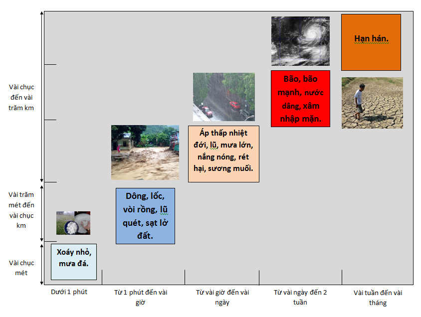
Các thiên tai khác nhau có những đặc trưng về quy mô không gian và quy mô thời gian khác nhau được tổng hợp trong hình 1. Những xoáy bụi nhỏ hay mưa đã có thể xảy ra trong vài phút và ở một khu vực nhỏ khoảng vài chục đến vài trăm mét. Những trận dông hay lũ quét có thể xảy ra ở quy mô lớn hơn nhưng cũng chỉ kéo dài vài giờ. Đối với áp thấp nhiệt đới, mưa lớn, lũ hay nắng nóng có thể xảy ra trên diện rộng từ vài chục đến vài trăm km và kéo dài trong vài giờ cho tới vài ngày; những cơn bão mạnh có thể duy trì lâu hơn kể từ khi hình thành đến khi tan rã. Trong dự báo, người ta căn cứ vào quy mô thời gian tồn tại của các hiện tượng để biết được hiện tượng đó có thể dự báo trước được bao lâu; đối với những hiện tượng xảy ra dưới một giờ như dông, lốc, mưa đá, lũ quét, sạt lở đất thì chỉ có thể cảnh báo trước một thời gian rất ngắn, tính bằng phút. Ngoài ra, quy mô không gian quyết định xem một hiện tượng có thể dự báo được hay không, nếu hiện tượng có quy mô dưới 10 km thì rất khó cảnh báo bởi các phương tiện đo đạc hiện tại không cho phép phát hiện ra những hiện tượng nhỏ như thế.
Nepartak Ensemble Track Forecast from JMA
Nepartak (1601) - Scatterometer wind estimation
This is the latest picture of scatterometer winds of Typhoon Nepartak at 1830 UTC 05 July 2016.
The scatterometer winds (in arrows or flags), with an infrared satellite image (from METEOSAT, GOES or Himawari) and numerical weather prediction model forecast winds from ECMWF in green arrows or flags. These model winds are valid at the time of observation.
A calm indicator circle is plotted if the wind speed is less than 0.5 m/s. The scatterometer winds are coloured according to the Beaufort scale, winds up to 5 Bft. (10.7 m/s) are in red, winds as of 6 Bft. are coloured as shown in the legend below the picture.
The exact data acquisition time is plotted in red next to the satellite swath.
The coloured dots give the value of the Maximum Likelihood Estimator (MLE) which indicates how well an observation fits to the Geophysical Model Function. High MLE values usually indicate high spatial wind variability or rain presence in the Wind Vector Cell.
A calm indicator circle is plotted if the wind speed is less than 0.5 m/s. The scatterometer winds are coloured according to the Beaufort scale, winds up to 5 Bft. (10.7 m/s) are in red, winds as of 6 Bft. are coloured as shown in the legend below the picture.
The exact data acquisition time is plotted in red next to the satellite swath.
The coloured dots give the value of the Maximum Likelihood Estimator (MLE) which indicates how well an observation fits to the Geophysical Model Function. High MLE values usually indicate high spatial wind variability or rain presence in the Wind Vector Cell.
BoM's tropical cyclone track forecast
This version of the video uses an example from Queensland
Typhoon Rammasun hits the Philippines
Authorities said at least 10 people had been killed by the storm.
Strong winds knocked out power and forced thousands of people to evacuate as Typhoon Rammasun hit the central Philippines.
The typhoon, also known as Glenda, struck the main island of Luzon with gusts of up to 185km/h (115 mph).
Millions without power
Town halls had been converted into shelters and evacuees had also been taken to schools and gymnasiums.
"Trees are starting to fall down and everything is just rain and wind," eyewitness Zhey Anzures told the BBC from a Manila suburb.
"We are also just beside a construction site and the cranes are really rotating because of the strong winds."
Manila Electric Company said 2.3 million of its customers were without electricity.
The Philippines is hit by around 20 major storms a year. Typhoon Rammasun is the first to make landfall this year after the rainy season began in June.
Typhoon Haiyan, which devastated the country last year, killed more than 6,000 people and was said to be one of the worst storms on record.
Strong winds knocked out power and forced thousands of people to evacuate as Typhoon Rammasun hit the central Philippines.
The typhoon, also known as Glenda, struck the main island of Luzon with gusts of up to 185km/h (115 mph).
Millions without power
Town halls had been converted into shelters and evacuees had also been taken to schools and gymnasiums.
"Trees are starting to fall down and everything is just rain and wind," eyewitness Zhey Anzures told the BBC from a Manila suburb.
"We are also just beside a construction site and the cranes are really rotating because of the strong winds."
Manila Electric Company said 2.3 million of its customers were without electricity.
The Philippines is hit by around 20 major storms a year. Typhoon Rammasun is the first to make landfall this year after the rainy season began in June.
Typhoon Haiyan, which devastated the country last year, killed more than 6,000 people and was said to be one of the worst storms on record.
Which Tropical Cyclones Are Similar to Typhoon Rammasun
Here is the two candidates:
1. Typhoon Elsie, October 1989.
Formed higher, also gained typhoon intensity (Vmax >= 64kts) when made landfall in Luzon island, Philippine but after passing longitude of 115E, Elsie has weaken and made landfall about 17-18N of Vietnam with tropical depression intensity.
2. Typhoon Angela, October 1995
Formed lower and further to 145 degree East, gained typhoon intensity when passing 135E and kept intensifying and begin to degrade after longitude of 113E. Angela was downgraded and completely dissipated when moving into Bac Bo gulf.
3. What's my forecast for typh. Rammasun?
- Rammasun will continue its way straight forward into Bac Bo gulf after passing Hainnan island while keep its intensity at severe tropical storm or weak typhoon. It means that Rammasun will move further north and stronger than its two cousins.
- The difference in month between Rammasun and its cousins also suggest that Rammasun will go further north.
... much more information need to be justified but impossible with those two track maps.
1. Typhoon Elsie, October 1989.
Formed higher, also gained typhoon intensity (Vmax >= 64kts) when made landfall in Luzon island, Philippine but after passing longitude of 115E, Elsie has weaken and made landfall about 17-18N of Vietnam with tropical depression intensity.
![]() |
| Typh. Elsie is similar to typh. Rammasun but seem to get weaker after passing 115 degree East |
Formed lower and further to 145 degree East, gained typhoon intensity when passing 135E and kept intensifying and begin to degrade after longitude of 113E. Angela was downgraded and completely dissipated when moving into Bac Bo gulf.
3. What's my forecast for typh. Rammasun?
- Rammasun will continue its way straight forward into Bac Bo gulf after passing Hainnan island while keep its intensity at severe tropical storm or weak typhoon. It means that Rammasun will move further north and stronger than its two cousins.
- The difference in month between Rammasun and its cousins also suggest that Rammasun will go further north.
... much more information need to be justified but impossible with those two track maps.
Subscribe to:
Posts (Atom)