Showing posts with label Climate. Show all posts

Humans are still significantly better at predicting the weather than AI

Artificial intelligence is present in almost every aspect of our daily lives. It's used in search engines, email clients, media platforms, and even grocery chains worldwide. It arguably makes the world a more efficient place, but not without costs; job loss being one of them. However, there is one industry that still struggles to fully automate: weather forecasting.


Despite all the progress that has been made in the realm of technology, AI, and machine learning, weather companies have not yet handed over the keys to their computer counterparts. While AI models, with the help of weather satellites like GOES-16 and 17, are capable of predicting minor weather changes and patterns with surprising accuracy, their efficiency takes a steep dive when major climate disruptions occur.

These major weather shifts, including natural disasters, often have warning signs that are too subtle and small in scale for most models to detect. Even when they are detected, models can't always draw correlations between early indicators of, say, a waterspout and its likely arrival. This, Wired reports, usually requires the practiced eye of an industry veteran. The outlet claims that, based on over two decades worth of weather prediction information (gathered by the NOAA Weather Prediction Service), humans outperform two of the most popular national weather prediction models; the Global Forecast System and the North American Mesoscale Forecast System.

By how much? Between 20 and 40 percent.

That is no small gap, and it could easily mean the difference between life and death for those in the path of a vicious tornado, waterspout, or rapid-onset blizzard. Having access to accurate weather information as early as possible is what makes evacuation (where necessary) or shelter-in-place recommendations viable.

Seasoned weather veterans can look at the smallest details, like subtle shifts in atmospheric pressure, wind speed, or "available moisture," and draw higher-quality conclusions than their computerized counterparts. This is because, in many cases, weather prediction models don't weigh these measures as highly.

And frankly, that's no surprise. Computers are smart and getting smarter by the day, but they still lack something humans have always possessed: the ability to evaluate situations in a broader context. Bringing machines anywhere near parity with human memory and context awareness would require an immense amount of processing power that just isn't available widely at the moment. Only a handful of computers that might be capable of this are in development right now -- at least, in the US -- and weather groups aren't the only ones that want to use them.

In short: humans are actively being replaced across dozens of industries at an alarming rate, but for now, your local weatherman (or at least the group feeding him his data) is safe.

By  

Global temperature for 2016 to be the highest since 1891

The annual anomaly of the global average surface temperature for the year 2016 (i.e. the combined average of the near-surface air temperature over land and the sea surface temperature) is estimated at +0.46°C (note that this is preliminary result) above the 1981-2010 average, likely to become the warmest record for the 126-year period since 1891
In 2016, the monthly average air temperatures for January, February, March, April, June and July, and the seasonal average air temperatures for the boreal winter, spring, and summer were also the highest recorded since 1891.
Detail report can be download here: https://goo.gl/vYkGtO  

(From: Tokyo Climate Centre - TCC/ JMA)


Fig 1: Annual mean temperature anomaly in 2016

El Nino trở lại vào nửa cuối năm, tác động đến thời tiết Việt Nam vào cuối năm.

ENSO, El Nino, La Nina, weathervn


Ông Lê Thanh Hải, Phó Tổng giám đốc Trung tâm Khí tượng Thủy văn Quốc gia và ông Hoàng Phúc Lâm, Trưởng phòng Dự báo Khí tượng hạn vừa, hạn dài của Trung tâm Dự báo Khí tượng Thủy văn Trung ương chia sẻ với PV Tiền Phong thông tin mới nhất về sự trở lại của El Nino cũng như nhận định về tình hình thời tiết mùa mưa 2017 và cả mùa khô 2017-2018.

Nắng nóng không kéo dài

Thưa ông, nhận định mới nhất về sự trở lại của El Nino?
Ông Hoàng Phúc Lâm: Hầu hết các trung tâm dự báo trên thế giới nhận định, El Nino sẽ quay trở lại từ giữa năm 2017, sớm nhất vào tháng 5, một số Trung tâm nhận định tháng 7. Các Trung tâm dự báo trên thế giới cũng khá thống nhất cường độ El Nino lần này sẽ không mạnh như lần gần đây nhất.

April 2017 ENSO update: Tropical Pacific Ocean in Conflict

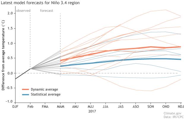
The tropical Pacific Ocean has been giving mixed signals recently, making a forecaster’s job even more difficult! In short, many of the computer models we use are predicting the development of El Niño over the next several months, but current conditions in the tropical Pacific aren’t showing many of the elements we’d expect ahead of a developing El Niño.

We’ve had neutral ENSO conditions since January, and forecasters predict that continued neutral is the most likely scenario through at least June. By September, chances of El Niño rise to about 50%, a slight edge over neutral (~40% chance) or La Niña (~10% chance).

What are forecasters seeing now?
We rely on prediction models because they provide the most likely evolution of the ENSO system better than we can compute on our own by eyeballing maps and charts and analyzing what has happened in the past under similar conditions.


Right now, many climate forecast models do predict the development of a full-fledged El Niño during this summer or fall. It’s likely that these models are acting on the much warmer-than-average waters near the coast of South America—the “Coastal El Niño” that I’ll get to a little bit later in this post. Predictions for the Niño3.4 region in the east-central Pacific, shown in the figure below, show chances for El Niño ramping up over the next year.


ENSO tác động như thế nào đến thời tiết, khí hậu Việt Nam?

ENSO là chữ viết tắt của các từ ghép El Nino và Dao động Nam (El Nino - Southern Oscillation ) để chỉ cả 2 hai hiện tượng El Nino và La Nina đặc trưng bởi dị thường nhiệt độ mặt nước biển, là hiện tượng trên đại dương và có liên quan với dao động của khí áp giữa 2 bờ phía Đông Thái Bình Dương với phía Tây Thái Bình Dương - Đông Ấn Độ Dương (Được gọi là Dao động Nam - dao động trong khí quyển) để phân biệt với dao động khí áp ở Bắc Đại Tây Dương).

ENSO, El Nino, La Nina, weathervn
So sánh phân bố nhiệt ở lớp bề mặt đại dương, hoàn lưu khí quyển trong khi ở trạng thái bình thường (A) và trạng thái El Nino (B)

Các vùng khí hậu Việt Nam

Phân vùng khí hậu tự nhiên của Việt Nam có 02 miền khí hậu: Miền Bắc và Miền Nam.
+ Miền khí hậu phía Bắc, ký hiệu là B;

+ Miền khí hậu phía Nam, ký hiệu là N.
Và 07 vùng khí hậu:

+ Vùng khí hậu phía tây Bắc Bộ, ký hiệu BI;

+ Vùng khí hậu phía đông Bắc Bộ, ký hiệu BII;

+ Vùng khí hậu đồng bằng và trung du Bắc Bộ, ký hiệu BIII;

+ Vùng khí hậu bắc Trung Bộ, ký hiệu BIV;

+ Vùng khí hậu Trung và Nam Trung Bộ, ký hiệu NI;

+ Vùng khí hậu Tây Nguyên, ký hiệu NII;

+ Vùng khí hậu Nam Bộ, ký hiệu NIII.


Forecasting for Catastrophes: How Investment in Weather Services Can Save Lives and Grow Economies


In fact, for the past decade, the World Bank and the Global Facility for Disaster Reduction and Recovery (GFDRR) have been working with assorted partners to increase awareness of, and investment in, the hydromet sector. GFDRR’s Hydromet team and the World Bank have partnered with leading national meteorological services across the globe – including agencies from Austria, China, Finland, Japan, Switzerland, Sweden, United Kingdom, and United States – and work closely with the World Meteorological Organization (WMO).


“There’s been a recognition of the need to improve hydromet service delivery in vulnerable countries – a recognition that modernized hydromet systems can provide benefits and avert the loss of human life,” explains Petteri Taalas, Secretary-General of the WMO. “So, although much more remains to be done, there’s been a significant increase of investment in the sector.”

La Niña Draws to a Close

The 2008-2009 La Niña has drawn to a close and the Climate Prediction Center has officially called an end to the continued monitoring of this year’s event.

The 2008-2009 La Niña has drawn to a close, as indicated by the lack of a significant temperature anomoly in the equatorial Pacific.  Source:  NOAA

The 2008-2009 La Niña has drawn to a close. Image indicates sea surface water temperatures (top) and the departure from the average sea surface temperature (bottom). La Niña is indicative of cooler than normal (blue). The lack of a significant temperature anomaly in the equatorial Pacific indicates to scientists that this year's La Niña has come to an end. Image Source: NOAA

La Niña (Spanish for “the little girl”) is the term used to describe the period when the sea surface temperatures of the equatorial Pacific ocean are cooler than normal. This region of the ocean tends to waiver between periods that are warmer than average (referred to as “El Niño”) and warmer than average - La Niña . In between these extremes are relatively neutral periods where sea surface temperatures are within a degree or two of average. It is this neutral period that the Climate Prediction Center is indicating is now imminent.The end of the current La Niña indicates that the Pacific Northwest may begin to dry out and the south may return to near-normal rainfall patterns.La Niña tends to bring nearly opposite effects of El Niño to the United States — wetter than normal conditions across the Pacific Northwest and dryer and warmer than normal conditions across much of the southern tier. The impacts of El Niño and La Niña at these latitudes are most clearly seen in wintertime. In the continental U.S., during El Niño years, temperatures in the winter are warmer than normal in the North Central States, and cooler than normal in the Southeast and the Southwest. During a La Niña year, winter temperatures are warmer than normal in the Southeast and cooler than normal in the Northwest.It is unknown precisely when El Niño will return.

Forum on protecting Mekong Delta opens in Can Tho

An open-ended forum on preserving nature and local culture in the Mekong Delta while allowing sustainable development in the region started up in Can Tho City Friday.

At the first seminar, Professor Doan Canh of the Ho Chi Minh City Institute of Tropical Biology, warned that the region’s renowned diversity was threatened by excessive exploitation without regard for the consequences.

He said it was time to shift from exploitation for development to a preservation strategy for development.

The forum’s organizers are the Steering Board for the Southwestern Region, UNESCO’s Man and the Biosphere Program, Can Tho University and the World Wildlife Fund.

They will use the forum to build databases of biodiversity and traditional cultures in the Mekong Delta, and seek funding for developing creative ideas in the region’s national parks, nature reserves and biosphere reserves.

Ministry announces climate plan for agricultural sector

A programme to heighten the capacity of the agricultural sector to meet climate change challenges during the 2008 - 20 period was officially announced by the Ministry of Agriculture and Rural Development on Friday.

The goal of the programme is to ensure safety and stability for residents in coastal, mountainous areas, central and Mekong Delta provinces.

It aims to maintain 3.8 million hectares for rice cultivation of two crops each year, protect dyke systems, infrastructure facilities as well as public works.

To achieve this goal, the ministry will set up detailed action plans and come up with policies to support sustainable production in areas most affected by natural disasters.

A main task of the programme is to establish national technical standards on master plans, designs and construction for infrastructure facilities in the agricultural sector.

It also seeks to improve research capabilities and forecast impacts of climate change for agriculture, irrigation, forestry, aquaculture and rural development projects.

It will also speed up flood prevention and research projects for central provinces, the Hong and Mekong deltas as well as forest protection and development in upstream areas.

Viet Nam is one of the countries in the world facing a large number of natural disasters every year. According to the Ministry of Agriculture and Rural Development, over the last 10 years, Viet Nam has lost 1-1.5 per cent of its GDP and 700 lives each year due to natural disasters.

"The Vietnamese Government has paid attention to reducing and coping with climate change. The country has released a national programme to deal with the situation. From this, each ministry will develop its own plans," said Nguyen Xuan Hoc, deputy minister of Agriculture and Rural Development

May - High and low temperatures

To give you an idea, this is where temperatures should be on extreme during the day and night during June for the main centres.